Eyes in Space, Lives on Earth: How INSAT-3DS Tracked Cyclone Arnab
India's satellite-powered early-warning network helped authorities monitor the powerful storm, prepare coastal communities and organise precautionary evacuations.

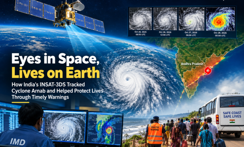
When nature turns unpredictable, timely information can make the difference between disaster and survival. As Very Severe Cyclonic Storm Arnab approached the Andhra Pradesh coastline in the early hours of October 28, 2026, India’s meteorological observation network was watching its every move.
Among the most important tools was INSAT-3DS, India’s advanced meteorological satellite, which provided repeated observations of the developing cyclone. Its imagery helped meteorologists monitor the storm’s cloud formations, movement, intensity and changing structure over the Bay of Bengal.
By _ https://indiainput.com Desk
This was more than a technological achievement. It was an important part of India’s preparedness to protect communities living along a vulnerable coastline.
⏩️ 𝗧𝗶𝗺𝗲𝗹𝗮𝗽𝘀𝗲 𝗼𝗳 𝗖𝘆𝗰𝗹𝗼𝗻𝗲 𝗔𝗿𝗻𝗮𝗯 𝗳𝗿𝗼𝗺 𝗜𝗦𝗥𝗢’𝘀 𝗜𝗡𝗦𝗔𝗧-𝟯𝗗𝗦 𝘀𝗮𝘁𝗲𝗹𝗹𝗶𝘁𝗲 🌀 Cyclone Arnab was a very severe class cyclonic storm that made landfall on Andhra Pradesh on the early hours of 28 October 2026. It was extensively imaged by India’s Geostationary satellite fleet including the INSAT-3DS meteorological satellite that imaged it at roughly 30 minute intervals to allow Indian authorities to track the cyclone live and take precautionary safety measures.
— ISRO Spaceflight (@ISROSpaceflight) October 30, 2026
Watching the storm, one image at a time
Unlike conventional satellites that capture limited snapshots of a region, geostationary meteorological satellites remain positioned over the same broad geographical area, enabling continuous weather surveillance.
INSAT-3DS observations, reported at approximately 30-minute intervals, offered meteorologists a regularly updated picture of Arnab’s development and movement. The satellite imagery was particularly valuable for identifying changes in cloud organisation and monitoring the cyclone as it moved closer to land.
The information was used alongside other meteorological inputs, including Doppler weather radar observations, surface measurements and numerical weather forecasts. Together, these tools helped the India Meteorological Department (IMD) refine its forecasts and communicate changing risk levels.
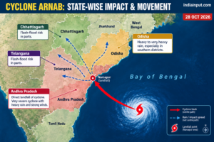
The warning system mattered because Arnab was no ordinary weather disturbance. It intensified into a Very Severe Cyclonic Storm, eventually crossing the Andhra Pradesh and Yanam coastline between Bapatla and Visakhapatnam.
At landfall, maximum sustained wind speeds were estimated at 125–135 kmph, with gusts reaching 150 kmph.
From satellite observations to ground-level action
Satellite images alone cannot evacuate a village or move a fishing boat to safety. Their real value lies in the decisions they help authorities make.
As the threat increased, the IMD issued successive weather bulletins and warnings. State and district administrations could use these forecasts to activate emergency response arrangements, communicate risks to vulnerable communities and organise precautionary evacuations.
According to Associated Press reporting, Andhra Pradesh authorities evacuated at least 180,000 people ahead of the cyclone. Fishing boats were secured, some train services were cancelled, and medical teams were deployed.
These measures illustrate the importance of connecting space-based observation with ground-level governance.
For coastal residents, timely warnings meant an opportunity to move away from vulnerable locations, seek shelter and protect essential belongings before destructive winds and heavy rainfall arrived.
Technology cannot stop a cyclone, but it can reduce its human cost
Arnab caused considerable damage to homes, agricultural land, roads and power infrastructure. Tragically, fatalities were also reported. Therefore, it would be inaccurate to claim that satellite technology prevented every casualty.
However, the scale of precautionary evacuation demonstrates how forecasting and early-warning systems can reduce people’s exposure to dangerous conditions.
India’s disaster-management capabilities have evolved significantly through investments in meteorological satellites, weather radars, forecasting models and communication networks.
INSAT-3DS represents an important component of this ecosystem. Developed by ISRO, it strengthens India’s ability to observe weather systems and support forecasting operations.
India’s space programme: A guardian beyond the clouds
The significance of INSAT-3DS extends beyond Cyclone Arnab. India’s meteorological satellite network supports weather forecasting, disaster preparedness, agriculture-related observations and environmental monitoring.
The collaboration between ISRO and IMD demonstrates how investments in space technology translate into practical public services. A satellite orbiting thousands of kilometres above Earth can provide information that helps administrators, emergency responders and citizens make decisions on the ground.
The lesson from Arnab is clear: disaster management begins long before a storm makes landfall.
The satellite observes. The meteorologists analyse. The administration responds. Citizens receive warnings and take precautions.
A timely image from space may look like a
swirling mass of clouds on a screen. But behind that image could be thousands of people moving to safer locations, fishing communities securing their boats and emergency teams preparing for the worst.
India cannot prevent cyclones from forming over the Bay of Bengal. But through science, technology, timely communication and public cooperation, it can work towards ensuring that fewer lives are placed at risk.
Sometimes, the most important rescue operation begins not on the ground, but thousands of kilometres above it.
SOURCE :
https://science.nasa.gov/earth/earth-observatory/arnab-strikes-india
FEEDBACK : Contact@indiainput.com
CATCHUP FOR MORE ON : https://indiainput.com