
Viral NASA Data : Bihar Shines 80% Brighter From Space!
NASA night-light map confirms a massive electrification success.
Viral NASA Data : Bihar Shines 80% Brighter From Space ! A series of satellite images released by NASA depicting Earth’s night-time lights has taken social media by storm, with Bihar emerging as one of the brightest spots in the Indian subcontinent.
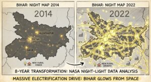
The data, which tracks changes in artificial night light over an eight-year period from 2014 to 2022, highlights a staggering transformation in the region’s luminosity. Once known for its dark rural stretches, the state now glows intensely, rivaling major global metropolitan hubs in light density.
By_ http://indiainput.com Desk
Diamond-like sparkle !
The viral images are part of a comprehensive analysis involving 1.16 million daily images processed by NASA scientists. This study was aimed at understanding human settlement patterns and energy consumption across the globe.
For India, and specifically the Bihar-Uttar Pradesh belt, the results have been described by internet users as nothing short of a diamond-like sparkle.
Social media platforms have been flooded with the high-definition composite views, with many users pointing out that the change reflects the rapid pace of rural electrification and infrastructure development over the last decade.
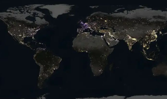
Earth isn’t just getting brighter—some areas are brightening and others are dimming because of changes in nighttime lights.
The finding comes from analyzing 1.16 million NASA satellite images taken every night for nine years. pic.twitter.com/1kFso4QE1k
— NASA Earth (@NASAEarth) April 16, 2026
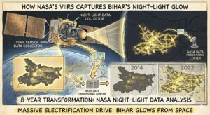
VIIRS
The technical backbone of this data comes from the Visible Infrared Imaging Radiometer Suite (VIIRS) on the Suomi NPP satellite. This instrument is sensitive enough to detect the glow from a single isolated highway lamp.
By comparing the 2014 baseline to the 2022 data, researchers observed a significant expansion in the “light footprint” of Bihar. This indicates not only an increase in the number of electrified households but also a rise in commercial activity and street lighting across previously underserved districts.
Energy Efficiency Studies
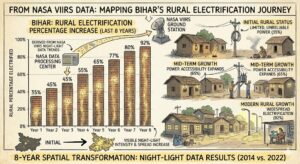
Economists and researchers often use night-light data as a proxy for economic growth and per-capita power consumption. The intense glow over Bihar suggests a major shift in the quality of life and accessibility to electricity.
While the maps have sparked immense pride among residents, they have also ignited discussions on the need for further studies into energy efficiency and the environmental impact of light pollution.
Changing Landscape
NASA’s Earth scientist Miguel Roman, who led the research team, noted that these maps provide the clearest yet composite view of human settlements.
For Bihar, the “8-year night-light map” serves as a digital testament to its changing landscape, proving that the state is no longer in the shadows but is firmly illuminated on the global stage.
SOURCE :
http://earthdata.nasa.gov/black-marble
http://state.bihar.gov.in/energy
FEEDBACK : contact@indiainput.com
CATCHUP FOR MORE ON : http://indiainput.com
Tired of RTO Red Tape? Kill the Paperwork
महिला आरक्षण 2026: क्या है अमित शाह का मास्टर प्लान?